One More Night and then Back to Marin

Wed, Mar  29, 2017

We arrived at the KOA in Moss Landing last night and what a great spot.  It’s right in the middle of Monterey Bay and about 100 yards from the beach.

My first order of business was to get a nice run in.  Google maps showed a trail along the dunes that looked enticing.  What it didn’t show was that it was soft loose sand.  Running was a chore but it sure felt great at the finish 🙂


IMG_2170

Our campsite is also about 200 yards from the wonderful Phil’s Fish Market & Eatery.  Cioppino anyone?


Dog Attack

Tue, Mar 28, 2017

Carol and I camped last night just outside of King City.  On Hwy 101.  Nice place with the wonderful Wildhorse Cafe next door.

This morning I went out for a run on Wildhorse Rd.  Picked it because it went up a hill and toward the vineyards.

Just as I was heading up the hill, three dogs came racing out of a decrepit property with all their teeth showing and barking like crazy.  And me?  I’m in the middle of the road minding my own business.

Three of them at 25, 35 and 45 lbs.  Normally in this situation, I’ll freeze and calm them down.  But not with these dogs.

So I’m back peddling like crazy and there’re nipping at my feet.  If I had fallen, I have no doubt that they’d have chomped into my legs or arms or whatever flesh they could grab.

The 25 pounder on my right bit my shoe half a dozen times and finally hit my ankle.  Small wound, a scratch really, but a teeth wound nonetheless and the possibility of rabies.

So finally I’m out of range and they head back home.  But what to do?

The rabies virus is no joke so I called 911.  Transferred to the Sheriff’s office.  The sheriff officer called me back and picked me up at the Wildhorse Cafe.  Then up the road to the scene.

I couldn’t have been more vindicated.  The officer drove into the driveway and seven (!) dogs came racing out.  Thumping into his car.  The officer could barely get out of that property with his squad car intact.  Crazy stuff.

He commented that he’s been on this road hundreds of times and has never seen them.  But while we were there, a pick-up going the other way stopped to say that he sees them every day.  Chasing cars.  And a laborer working on a construction project across the street told me that he’s been bitten and that they’re mucho problemo.

Back at the rig, I’m texting with animal control who wanted a picture.  As I said, it’s barely a scratch but here it is:

IMG_2163

Animal control told me that all animals at the property are current on vaccinations but I’m skeptical.  I also asked about laws around animal attacks.  Was told that if a bite occurs, quarantine.  Public protection from dogs can be leveled against the owner if I press charges.  I’ve never done that before but I won’t sleep well if I don’t.  So that’s what I’m going to do.

Here’s the offending critter.

IMG_2166

Easy Day

Fri, Mar 24, 2017

Sleep in.  Walk the dog on the beach.

IMG_2143

Lunch at Monarch Dunes Golf Club.  Hit a bucket of balls.  Back for a slow afternoon and then dinner.

Still wowing over the failure of the American Health Care Act to even reach a vote in the House.  Washington is a crazy place these days.

Pismo Beach

Thu, Mar 23, 2017

Today was an easy one as we travelled a mere 73 mi from our Santa Barbara RV park to Pismo Coast Village RV Resort.

With the winter rain, California’s country side has exploded with flowers and the hill sides look more like Ireland that what we’re come to know.  And the vineyards are also beautiful even though dormant this time of year.

About about half way here, a Jeep towing a Bambi (a single axel Airstream) pulled in front of us so I though I’d follow for a while.  Wondering whether he was going to the same place.  So we trailed him and sure enough, he brought us right here.  Nice 🙂

Here he is on Hwy 101:

_8012630

After settling in, TiVo and I headed to the beach.  A walk all of 50 yds.  Here’s our first view.  And a river separating us from the surf.  Looks like we’ll have to show that river who’s boss LOL

IMG_2141


Santa Barbara

Wed, Mar 22, 2017

After three wonderful days in Malibu, we moved up the road to Ocean Mesa RV and Campground that is about 20 miles west of Santa Barbara.

Ocean Mesa is also adjacent to the El Capitan State Beach and about 3 miles from the Refugio State Beach.  This area is a beautiful stretch of the CA coast.

IMG_2140

And then we were off to Santa Barbara for lunch on State Street.  Yes, it’s a tourist mecca but then again, we’re tourists.  I forgot to take a picture so I swiped this one from the web.

State Street courtesy paintyourlandscape


Sunday is Runday

Sun, Mar 19, 2017

Google maps is great for checking out local running routes.  Turns out there’s a nice trail just around the corner.

It’s Solstice Canyon in the Santa Monica Mountains National Recreation Area.  The plan was to run up the canyon until the road ends.  Then onto a single track and connect to some roads that work their way back to our RV park.

Beautiful weather in the high 60’s with the marine layer just burning off.  Totally reminded me of running Mt Tam in Mill Valley 🙂

So up I went where I found the Keller House ruins.  Early residents that lost their house to a fire.  Then connect to a single track and try to find the adjoining road.

But just as I approached the road, there are ‘no trespassing’ signs.  Typical Malibu mentality.  Buy some coveted property with public access and then fence it off.

I wasn’t turning back so on I went.  Found the road and headed down.  Then more signs about private property and ‘right to pass by permission from owner’.

Here’s the neighborhood.

IMG_2134

I eventually hit the main road and there’s a pile of mail.  Uh oh.  I’ve seen this before as we’ve been victimized by mail thieves.

So as I’m picking it up, half a dozen cars came by and no one’s gives a flip about it.  How can you drive by mail on the side of the road in your neighborhood and not be bothered?  Oh well, I called the Sheriff who sent someone up.  Hope the victim appreciates that he’s been informed that his mail was stolen.

Here’s the pile showing the junk mail.  But trust me, there’s a credit card envelope in their with the statement missing.  Someone better watch their accounts…

IMG_2135


Malibu Beach RV Park

Sat, Mar 18, 2017.

Yes, there really is such a thing.

Carol and I pulled into the Malibu Beach RV Park after fighting some nasty roads and nasty traffic in LA.  It was the usual suspects, i.e., the 5, the 405 and the 101.  In no other city are the highway numbers treated as nouns.  But here, they are.

This park is set on a bluff above PCH – that’s the Pacific Coast Highway – and has 5 rows of sites working their way up the bluff.  Not sure how it happened but we got a great spot in the front row 🙂

Here’s our site with a neighbor’s Airstream in the second row.

_8012589

With bright sunshine, 72F outside and a light breeze, what more could you ask?

Another Silver Yorkie

Fri, Mar 17, 2017

TiVo is our lovable Yorkie.  He’s also silver.  Never seen another one.  Until yesterday.

Carol and I were having lunch when a couple came in with their silver Yorkie. Cute little guy.  That’s him in the lower right next to our TiVo.

IMG_2123

Tough Drive Out of Death Valley

Thu, Mar 16, 2017

We bailed on Death Valley this morning.  Just too hot for camping without air conditioning.  Maybe when we were younger.  But not as retirees that know better 🙂

And no flowers 😩  Last year there was a Super Bloom and March set an all time attendance record.  So you can imagine how disappointed we were with no flowers this year.

So off we went to the west on Hwy 190.  Beautiful drive for me.  But not so much for Carol.  Her view of Death Valley is that ‘it’s ugly’ and ‘don’t go there’.  Too dry and desolate.

And then there’s the climb out of the valley.  Furnace Creek is 190 ft below sea level and the mountain pass is nearly 5,000 feet.  So it’s quite a hump.

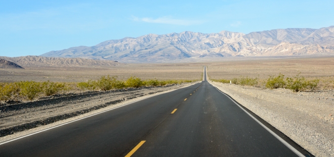
The first part was easy as it was up and across the valley.  Here’s a typical view.

_8012562

With lots of straight lines.  What could go wrong?

_8012570

And then we started the climb.

Going up was slow but not too bad.  Very little traffic and the Cayenne did great although I would have liked more power.  Then down the back side with guard rails protecting killer drop-offs.  Carol wasn’t amused.

She suffers high anxiety under normal conditions so this was a doozy.  And she was riding in the back.

I don’t have shots of the tight turns as both hands were on the wheel.  But here’s one and if you look in the center, you can see the highway crossing the next valley.  And is that Mr Whitney, the tallest point in the continental US, on the horizon?

_8012577

Then it was up and over the next range before we reached Hwy 395 and the Owens Valley.  Driving through stuff like this is fun for me but Carol couldn’t wait for it to end.  But end it did with this view of the Sierra on the approach to Hwy 395.

_8012585

And then we drove into Mojave for lunch and all was forgiven 🙂

Death Valley

Wed, Mar 15, 2017

Yesterday we decided to skip Furnace Creek since the campground doesn’t have any hook-ups.  That means no AC and the forecasted high today is 95 F.  But here we are.

I talked Carol into coming for one night since it’s smack dab right in the middle of Death Valley and I wanted to see it.  It also didn’t hurt that the temp drops quickly once the sun sets.  So that’s what we’re waiting on.

BTW, the resort is NOT dog friendly so we can’t go hang out at the bar and enjoy their AC.  Not with TiVo, we can’t.  So we’re sitting in the Airstream now at 4:30 pm waiting for it to cool off.

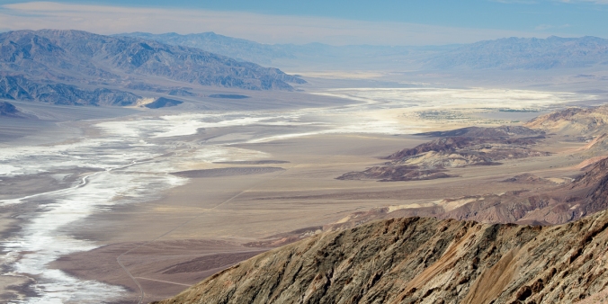
Earlier today, we did the easy drive from Tecopa Hot Springs up to Furnace Creek and it was nice, AC and all.  After setting up camp, we drove to two of the famous lookouts, Zabriskie Point and Dantes View.

Both look out into the valley.  Here’s Zabriskie Point:

_8012546

Right behind me were these beautiful hills with texture to die for:

_8012548

Then is was off for a 20 mi drive and 5,000 ft climb to Dantes View.  Darn haze ruined a beautiful view of the valley 😦

_8012550


Tecopa Hot Springs

Tue, Mar 14, 2017

We had plans to camp four nights in the RV park at the Furnace Creek Inn and Resort in Death Valley but the 95 F weather forecast had us more than just a little concerned.  So I called to ask if they could assign us to a spot with some shade.

After confirming the details of our stay, I heard the words that no RV’er ever wants to hear:  no hook-ups.  That means no water, no sewer and, most importantly, no power to run the air conditioner.  This is a nonstarter.

So Carol and I pulled over at the next town and started working the phones.  No vacancy in the rooms at the Furnace Creek Ranch Inn and Ranch.  And no hook-ups at any of the other campgrounds in the park.

So we kept searching and found the Tecopa Hot Springs.  Yes it’s outside of the park but it’s right on our way and there are three RV camps with FULL hook-ups.  And one of them had a satellite internet connection.  Yippee since there’s no phone service in town. All in all, not too bad and there’s a BBQ place within walking distance.

The high temp hit 97 F but it cooled off as soon as the sun went down.  And the overnight low of 53 meant we didn’t need the A/C.  Gotta love the desert for the day / night temperature swings.

Here’s a shot of the local terrain.  Death Valleyish, no?

IMG_2118

Calico Ghost Town

Mon, Mar 13, 2017

Carol and I woke up today at the Barstow / Calico KOA and were looking forward to a day of doing, well, next to nothing.  Just rest and relaxation.

What little ambition we had was to drive the 5 miles to the Calico Ghost Town.  A real tourist trap.  But the buffalo burger on the restaurant menu was all it took to get me to fire up the Cayenne and head over.
Calico was a silver mining town that was booming in the late 1800’s.  But the collapse in the price of silver killed it and the official population today is 8 people.

Overall, I was very surprised by how well preserved it is.  But then again, this is the Mojave desert.

IMG_2105

Hello USA

Sun, Mar 12, 2017

Carol and I crossed back into the US on Thursday.  Easy crossing at Tecate and then a weekend with friends in San Diego.

Three days blew by and then we packed up and headed up I-15 to Barstow, about half way to Death Valley.

When we passed through the Lake Elsinore area, traffic ground to a halt.  Turns out that there’s a super bloom of Poppies.  I took this photo out the window and wish I’d done a better job.  It was stunning.

IMG_2099

No Bad Days

Thur, Mar 9, 2017

There’s a saying down in the Baja that pretty much sums it up: No Bad Days.

Since I wholeheartedly agree, I couldn’t resist the bumper sticker. Stuck it on our Airstream right at the front door.

_8012507

Baja and the Left Turn Signal

Wed, Mar 8, 2017

There’s a rule of the road in Baja that I’ve never seen anywhere else.

Left turn signals aren’t used to indicate a  left turn. If that’s what you want, you take control of the left lane, slow and make your turn. Traffic behind you passes unimpeded on your right. Simple, no?

So what’s the left turn signal for? It’s to indicate to a trailing car that it’s ok to pass. You are taking on some liability so you better get this right.

It was early in our Baja trip and one of the drivers in our caravan didn’t get the memo. So every time a car came up behind him, on went the blinker. Never mind whether he was in a passing zone or whether he could see if it was clear ahead. If a car came up, he turned on his left turn signal.

We somehow survived a very serious situation.

I was following our RV’er when a pick-up passed me so that he was between us. Our RV’er was driving a class A motorhome and pulling a full size pick-up so he was probably 60’ in length, i.e., a pass would need a lot of clearance and a lot of time.  Class A’s are tall like a bus so I couldn’t see anything in front of him.

On went the blinker and the pick-up started to go around.

A few moments later, a third car appeared on the far left coming in our direction with his right wheels off the road.  Yes, the pick-up trusted the left turn signal and yes, there was an oncoming car.  They were three wide on a road barely capable of two cars. And no shoulder.  How they avoided a collision I do not know.

My next thought was that the third car would come back on the road, cross the centerline and nail us head-on. Definitely a code brown situation.

Here’s a typical shot of the Hwy 1 with no shoulder.  Can you imagine a Class A motorhome, a pick-up and a sedan all side-by-side?  We saw it and that visual is forever stamped in my brain.

IMG_2047

Potholes on Hwy 1

Wed, Mar 8, 2017

You’d think that Mexico would be proud of their Federal Hwy 1 and do a good job of keeping it in shape. Not so.

Although there are sections of the highway that are in great shape with a wide shoulder, most of the road is very narrow and full of potholes.  And this is where a caravan with CB radio’s comes into play:  The lead driver calls then out as we drive along.

When you approach a section of chunky road, the strategy is to slalom around them but that doesn’t work when they cover the width of the lane. Then it’s across the centerline so long as there’s no oncoming traffic. If there is, just suck it up, go right over them and hope for the best.

One of the rigs in our caravan wasn’t so lucky as one of the leaf springs supporting his axels snapped. Luckily, he was only about 20 miles from a suspension shop and he was able to get it repaired.

Here’s a pic of some nasty ones.  Hit these at full speed and it’s a flat, bent rim or suspension damage.  Nice, eh?

Ensenada Potholes


Oncoming Big Rigs

Tue, Mar 7, 2017

Our Airstream is 8’-8” wide and I’m told that’s the legal limit.  Big Rig’s are also 8′-8″ and that’s also about the width of Mexican Hwy 1.

Whenever we’d encounter an oncoming big rig, I slide to the right as much as possible trying not to let the Airstream wheels drop off the side of the road. This was not always easy as the Airstream wheels are wider than the Cayenne and I know they went off more than a few times.

Alternatively, one could hold your position in the center of the lane but that brings a side swipe into play.  No one suffered that fate but one person lost their side view mirror to a big rig.

Here’s a pic of our Airstream that does a nice job of illustrating the problem.

IMG_2274.JPG

Whale Watching or Whale Touching?

Mon, Mar 6, 2017

There’s whale watching and then there’s whale touching. Lots of the former in US territorial waters but for the latter, head down to Baja.

We are camped near the Pacific Ocean at the Malarrimo RV Park in Guerrero Negro.

Guerrero Negro is famous for its salt farm and for Scammon’s Lagoon, fertile breeding grounds for gray whales.

Whale watching is big business here and we were told that the calves will approach the boats so that you can pet them. And they weren’t kidding.

We entered the bay and the whales were everywhere. Never mind that we missed the peak as the Alaska migration was already underway.

As our pilot approached the whales, he cut the engine to coast in. We were told that tapping on the side of the boat would attract them and sure enough, the momma / calf pair came right in. Momma stays close by to ensure the safety of her baby and she bumped our boat a few times to let us know that she’s there and she cares.

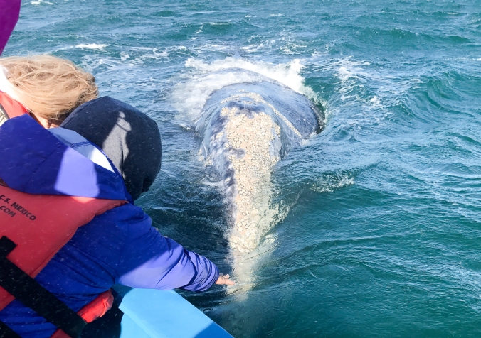
Here’s a calf that put his/her head right on the rail within a foot of my hand.  I couldn’t resist to give her snout a touch.  Felt a bit like a neoprene wetsuit only different.  Here she is on the approach with momma just on the left.

IMG_1956

Here’s an adult with her snout covered in barnacles.  They all have them.

IMG_1968

Getting this close to whales isn’t without it’s issues.  Being mammals, they breath and it’s in through the nose.  And when the exhale, it’s out their nose.

If you are close to and downwind when a whale blows, you get, well, a snot shower.  Ask me how I know.  Face, coat, everything covered in salty stuff.  Oh well, no complaining here.

This wasn’t the direct hit that I experienced but there’s a reason this fellow has turned his head.

IMG_2014

Ironwood Carvings

Sun, Mar 5, 2017

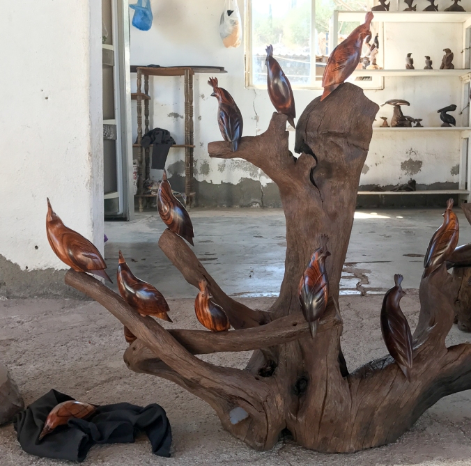
Since Santispac Beach is 13 miles from Mulegé, vendors step up to supply the goods.  The fish mongers, veggie sellers, bakery goods, water suppliers, etc.  Another is a family that carves ironwood.

Copying from Wikipedia, Mexican ironwood carvings is a handcraft that began with the Seri indigenous people of the state of Sonora. The wood comes from Olneya tesota, a Sonora Desert tree commonly called ironwood . It is a slow growing important shade tree found in northwest Mexico and the southwest U.S. The wood it produces is so dense that it lacks air bubbles and sinks in water.

We met Carlos and his father on our way down but didn’t buy anything.  Now that our trip is about to wrap up, I thought is was high time to support the local merchants.

Carol was on board and wanted a 15″ palm tree with 14 leaves.  Each is removable for storage and it’s a beautiful piece.  We also picked up a small whale tail, always loved that phrase since it’s used to describe the spoilers on classic Porsche 911’s.

Our buddies also picked up a tree of quail, a scene with turtles, a whale and an eagle.  Beautiful stuff.

We visited his studio where I shot these pics.

IMG_1883

IMG_1885

IMG_1887

Loose Dogs in Loreto

Sat, Mar 4, 2017

Not much to say about Loreto. Nice fishing village, tiny RV park and lots of loose dogs.

When Carol and I took TiVo for a walk, a small dog came rushing up to him. Carol screams “Keep him away! He’s probably not vaccinated!”. Probably??

IMG_1867

Road Construction Baja Style

Fri, Mar 3, 2017

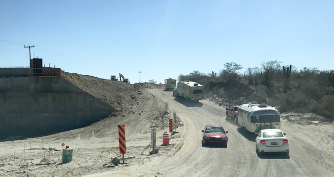
Mexico’s Hwy 1 is under construction in a lot of places. This means that you detour onto a dirt road. It’s mostly not too bad. But there’s plenty of dust and washboard.

Here’s an example:

img_1856

And then there’s the bridge construction zone.  The road down into the riverbed was pretty steep but we had enough traction to get up the bank and back onto the road.

We were chatting with a couple that drove that area during the rain a couple of weeks ago.  They said that even pick-up trucks were stuck in the mud. Had we been there on that day, we wouldn’t have had a chance.  Not with our 6,500 lb trailers.

Here’s the scene that I posted when we drove it.  Wish I had a shot on the muddy day.  Well, maybe not.

road-construction

Back to Santispac Beach

Thu, Mar 2, 2017

We spent three nights at Santispac Beach on the way down and we’re back for  three more nights.

We love this place.  Fish mongers work the beach each morning offering shrimp, scallops, crab meat, red snapper and other delicious items.  All pretty cheap with the kilo prices at 200 pesos, i.e., $10 USD.

A cool breeze greets you each morning and jeep trails to run or hike.  Mulegé is about 13 miles away with wi-fi, great restaurants and an laundromat.

This shot of the beach will help illustrate why it’s so popular.

_8012504

And the beautiful houses from the upper left corner of the pic above.

img_1876

And finally a nice sunset.

_8012497

Topes and Topesitas

Thu, Mar 2, 1017

Our route couldn’t have been easier. Cross the border in Tecate, follow Hwy 3 to Ensenada and head south on Hwy 1. Stay on Hwy 1 to Cabo San Lucas. Rinse and repeat. Easy Peasy.

But then there are the Topes (‘toe-pas’). We know them as speed bumps and they are everywhere. How else to slow highway traffic that passes through a small town or village? A stoplight or traffic circle? No chance.

Some are Tope Grande that’ll rip apart your suspension. Others are Topesitas that are hardly worth slowing for.

Sometimes they are signed and sometimes not. Sometimes they are painted yellow and sometimes not. And sometimes they are fake, ie, yellow stripes but no bump. Just play it safe and avoid an oopsie.

Here’s an example that’s properly signed.  You don’t want to hit a Tope Grande at highways speeds…

img_1881

Carnival at La Paz

Wed, Mar 1, 2917

Last night was Fat Tuesday and La Paz put on quite a parade.  Nothing like Fat Tuesday in New Orleans as this was a G rated affair.   But boy did they turn out.

The parade was nearly a hour long and the floats were populated mainly by middle grade and high schoolers.  And lots of beautiful Señoritas.

But darn, it sure would be nice if they’d put that much effort into their roads, electrical grid and cell phone towers 😦

3

2

1